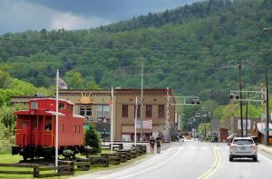
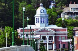
Hot Springs, North Carolina Historic Markers
One marker commemorates the time when this area was occupied by the Cherokee. A second commemorates the hot springs which were discovered by those natives and became the draw for settlers during colonial times and tourists in later centuries. Those hot springs led to a succession of hotels, one of which is commemorated by another historic marker on the Civil War Trails (which is described on a separate page). Another is representative of the rich cultural history that can be found not only in Hot Springs but in the entire county–one recognizing the contribution of a woman to the preservation of traditional ballads in the early 20th century. Hot Springs cultural history extends to its place in educational history with the foundation of a school which today in nearby Asheville continues the preservation of the area’s cultural heritage.
Paint Rock
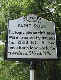
Inscription reads: Pictographs on cliff face were created by Indians ca. 2500 B.C. & long have been landmark for travelers. 5 1/2 mi. N.W.
Location: The marker itself is just south of the town of Hot Springs at the intersection of US 25/70 and River Road. GPS Location: 35° 53.614′ N, 82° 49.273′ W. Travel on River Road for 5 1/2 miles to the actual location of the rock.
History: Paint Rock is recognized to be North Carolina’s best known example of an American Indian pictograph. Testing in 2006 has indicated that the petroglyphs were created about 5,000 years ago. The pigments were found to be of superior quality and complex design, and the ingredients were definitely local.
An explanation offered for the creation of this art in this particular location stems from the nearby hot springs which the Cherokee Indians were the first to use. The Indians (as well as settlers and tourists in later years) believed that the hot springs possessed healing powers. Research indicates that the Indians made rock art sites as stopping points on their way to hot springs as places for prayer and contemplation on their pilgrimage to the springs. It could be that Paint Rock served such a purpose.
To view the panel of Paint Rock, park in the area on the left at the point where the gravel road curves sharply to the right. (The road will soon be a paved road into Tennessee.) You should then walk back about 50 yards and look up about 30 feet at the cliff on the other side of the road (with your back to the French Broad River). You should see alternating red and yellow rectilinear lines painted against the vertical cliff face. The pictographs have incurred damage from both the weather and campfire soot and are not easy to spot.
This area was also the site of a block house for guards to protect early settlers from Indians in the late 1700s because of its strategic location. The junction of the French Broad River near Paint Rock with an old road immediately in front of the site made it the perfect site for a major route through the mountains.
HOT SPRINGS
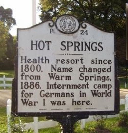
Inscription reads: Health resort since 1800. Name changed from Warm Springs, 1886. Internment camp for Germans in World War I was here.
Location: On the main street (Bridge Street) in the town of Hot Springs just as you enter town from the south after crossing the French Broad River–in front of the current location of the Hot Springs Spa and Resort. GPS Location: 35° 53.615′ N, 82° 49.517′ W.
History: Although artifacts found here tell us that the Cherokee Indians used these springs earlier, the natural hot mineral springs were “discovered” in 1778 by a group of mountaineer white settlers. The combination of the springs and their location on a road that took travelers and, later, drovers with livestock, through this area led to the development of first a tavern and then a succession of hotels. The first hotel called The Depot (built in the late 1700s) was bought in 1832 by James and John Patton who made extensive improvements to it and renamed it The Patton. It was one of the most beautiful resort hotels in the East with the second largest ballroom in the state and during the summer season attracted as many as 1,000 visitors at a time. For the role played in the Civil War by this property, go to the Hot Springs: Warm Springs Hotel on the Civil War Trails page. After the Civil War, Col. J. H. Rumbough purchased the hotel and springs and the resort became a fashionable destination point mainly with the direction of his wife, Carrie. Its popularity increased when access became easier with the expansion of railroad service through Hot Springs. Unfortunately when the Patton was destroyed by fire in1884, Rumbough lacked the funds to rebuild and sold the property to the Southern Improvement Company.
The company spent great sums of money constructing a four story hotel and opened Mountain Park Hotel in 1884. The hotel was done in an elegant Swiss style of architecture with the latest styled Mansard roof. There were 200 bedrooms all lighted by electricity and heated by steam. They added the first golf course in North Carolina—a nine-hole course called the Wana Luna. The tees and greens were square. They also put a bathhouse over the springs. The modern bathhouse held 16 marble pools–each one measuring 9 feet long, 6 feet wide and up to 6 feet deep. After a bath, the patient could walk to another room and receive a massage or other treatment depending on his condition. The typical treatment plan consisted of 21 days of baths and massage therapy.
The Southern Improvement Company went bankrupt in the process of rebuilding the resort and offered the property back to Col. Rumbough. He bought it and once again became owner and manager for the famous hotel. Things went well with the Mountain Park until the outbreak of World War I. Carrie Rumbaugh died in 1913 and travel to the hotel slowed considerably. So, Col. Rumbough negotiated a contract with the War Department to house Germans who were in N.Y. Harbor on luxury liners when war was declared. Consequently, 2500 passengers, officers and crew members came to Hot Springs.
And the grounds of the hotel were transformed into a German Village as the German men constructed buildings. The brass band from the ship practiced each day and gave concerts for the townspeople every Sunday afternoon. When the armistice was announced, the German band played all night. Many of them came back after the war with their families because of the warm friendships that had developed with the townspeople of Hot Springs. In January 1920, the elegant hotel burned and ended an era of the fancy resort life. When Col. Rumbough died in 1924, his daughter, Bessie Safford, acquired the property and built The Hot Springs Inn. She struggled with the property and in 1940, the hotel property with the springs and 100 acres of land was sold to a group of Marshall business men. It was operated off and on for several years and fell into decline. The Rudisill family bought the property in 1956 and in 1977 still another fire burned the current hotel. Then in 1990, Gene Hicks, a Madison County native, and his wife, Anne, purchased and renovated the neglected property and still own it today.
For more history of this property check out this link here.
BALLADRY
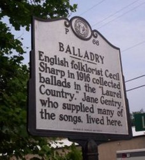
Inscription reads: English folklorist Cecil Sharp in 1916 collected ballads in the “Laurel Country.” Jane Gentry, who supplied many of the songs, lived here.
Location: At the intersection of Walnut Street and Bridge Street right in downtown Hot Springs. GPS Location: 35° 53.501′ N, 82° 49.793′ W.
History: Madison County has been called the richest repository of English folksongs in the world. This quote is from Cecil Sharp, an English folklorist, who traveled to Madison County in 1916 to collect ballads from its residents. Cecil Sharp and his assistant, Maud Karpeles, spent four weeks traveling around Madison County collecting the music passed down through the generations from the British and Scottish settlers of the area. He was told about the area by Olive Campbell (wife of John C Campbell who established the Folk School in nearby Brasstown, N.C.) Mrs. Campbell had already collected over 200 songs and ballads. The principal of Dorland Bell School in Hot Springs had written to Sharp about Jane Hicks Gentry and Sharp collected more songs from her than from any of the other singers. Of the total 260 songs, he collected 70 songs from Jane Gentry of the 102 songs collected in Hot Springs.
Betty Smith, a local resident who herself sings ballads accompanied by traditional instruments, is the author of Jane Hicks Gentry: A Singer Among Singers. For more information about Madison County’s rich traditional music heritage, go to the Traditional Music section of the website.
Her home which is visible behind the Historic Marker is now a private residence.
DORLAND BELL INSTITUTE
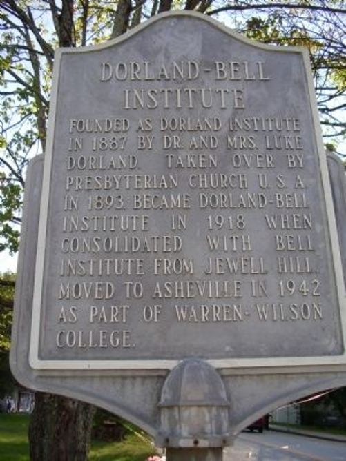
Inscription reads: Founded as Dorland Institute in 1887 by Dr. and Mrs. Luke Dorland. Taken over by Presbyterian Church U.S.A. in 1893. Became Dorland-Bell Institute in 1918 when consolidated with Bell Institute from Jewell Hill. Moved to Asheville in 1942 as part of Warren-Wilson College.
Location: On Bridge Street right in downtown Hot Springs at the intersection of Walnut Street. GPS Location: 35° 53.536′ N, 82° 49.704′ W.
History: In 1886, Presbyterian missionaries and educators Luke and Juliette Dorland retired to Hot Springs, North Carolina. Residents here asked them to teach their children and soon the Dorlands had 25 students in their home using money granted from the Presbyterian Board of Home Missions for books and equipment. When the number of students grew, the Dorlands built a two-story frame schoolhouse at their own expense. By 1894, the school, known as the Dorland Institute, had grown to include a girls dormitory, an expanded schoolhouse, and additional teachers. In 1918, the Dorland Institute consolidated with the Bell Institute, a large day school for girls and included seven acres of land, boarding facilities for 100 girls in the village, and a 300-acre farm with housing for 40 boys. Girls at the school received an education of “head, hand and heart,” which stemmed from their Presbyterian roots. Students worked on campus, performing such tasks as cooking, cleaning, and other daily duties that taught maturity and responsibility. The history of Dorland-Bell is a capsule of the story of the wider Presbyterian mission in the Southern Appalachians to establish schools and hospitals. When Dorland-Bell closed in 1942, it merged with the Asheville Farm School to become Warren Wilson College.
A local author, Jacqueline Burgin Painter, has written The Season of Dorland-Bell:History of an Appalachian Mission School detailing the history of this Institute.
ROBERT E LEE DIXIE HIGHWAY
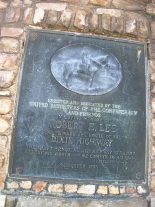
Inscription reads: Erected and dedicated by the United Daughters of the Confederacy and friends in loving memory of Robert E. Lee and to mark the route of the Dixie Highway “The shaft memorial and highway straight attest his worth- he cometh to his own” Littlefield
Location: On US Highway 25/70 leaving Hot Springs going north at the intersection of South Serpentine. GPS Location: 35° 53.462′ N, 82° 49.907′ W
History: The Dixie Highway was first planned in 1914, inspired by the example of the Lincoln Highway. The road was part of the National Auto Trail system and initially was intended to connect the Midwest with the South. However, the final result is more of small network of interconnected paved roads, rather than a single highway. It was constructed and expanded from 1915 to 1927.
The eastern route of the Dixie Highway mostly became U.S. Highway 25 and in Madison County that runs through the towns of Marshall and Hot Springs. Here and in a few other towns in Western North Carolina in the late 1920s, the United Daughters of the Confederacy placed bronze plaques on granite pillars to mark the route of the Dixie Highway (and honor General Robert E. Lee). The other locations are in Asheville, Fletcher and Hendersonville, and on the NC/SC and NC/TN state lines.